


GR400-J4

dudu79
User
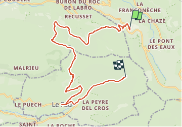

Length
18.8 km

Max alt
1548 m

Uphill gradient
957 m
Km-Effort
31 km

Min alt
938 m

Downhill gradient
862 m
Boucle
No
Creation date :
2022-08-29 16:31:20.081
Updated on :
2022-08-29 16:39:44.348
0m
Difficulty : Unknown

FREE GPS app for hiking
 SityTrail
IGN / Geographical institutes
SityTrail Plus
The world is yours!
About
Trail Trail of 18.8 km to be discovered at Auvergne-Rhône-Alpes, Cantal, Le Falgoux. This trail is proposed by dudu79.
Positioning
Country:
France
Region :
Auvergne-Rhône-Alpes
Department/Province :
Cantal
Municipality :
Le Falgoux
Location:
Unknown
Start:(Dec)
Start:(UTM)
470951 ; 4998483 (31T) N.
Comments